Fort St. John Pilot Project
|
|
Fort St. John Pilot Project |
|
| ||||||||||||||||||||||||||||||||||||||||||||||||||||||||||||||||||||||||||||||||
|
NATURAL DISTURBANCE BLOCK DESIGN WORKBOOK by Craig DeLong Regional Ecologist Ministry of Forests Prince George Region May 1999
INTRODUCTION Public criticism of past practices and better
understanding of natural systems has resulted in the emergence of new
ideas about forest management (Maser 1988; Franklin 1989, Hansen et al.
1991). One such idea is that managed disturbances should be designed to
approximate natural disturbance regimes. This suggestion is derived in
part from emerging evidence that disturbance has a key ecological role in
many forested ecosystems (Zackrisson 1977, Van Wagner 1978, Hessburg et
al. 1994). The underlying assumption is that the biota of a forest is
adapted to natural disturbances and thus could cope more easily with the
ecological changes associated with timber harvest if the patterns created
resemble those of natural disturbances (Hunter 1993, Swanson et al. 1993,
Bunnell 1995). The Biodiversity Guidebook (1995) which outlines a process
for meeting biodiversity objectives as required in the Forest Practices
Code of British Columbia Act and Regulations is based on this
approach. Natural disturbances maintain plant and animal
diversity over time and space by maintaining structural complexity within
stands and by influencing the size, distribution, edge characteristics,
and dispersion of stands across the landscape (Zackrisson 1977, Hansen et
al. 1991, Hessburg et al. 1994). The size, shape, and location of
individual forest patches or stands profoundly affect landscape stability
and productivity (Franklin and Forman 1987, Frank and McNaughton 1991).
Legacies of natural disturbance such as old large diameter trees, snags
and woody debris play a fundamental role in maintaining the long term
ecological functioning of the ecosystem (Hansen et. al. 1991, Maser 1992,
Franklin 1994, Ammaranthus 1994). The
impacts of forest management appear now to have a greater influence on
landscape pattern than those of natural disturbance agents (DeLong and
Tanner 1996, Zackrisson 1977). Hence, there is a need to utilize
information collected from studies of natural disturbance to assist forest
managers in incorporating some design considerations into future harvest
openings in order to reduce the functional dissimilarities between
harvested and natural openings. This
workbook is intended to provide some considerations for design of larger
or aggregate harvest openings based on studies conducted within the
Sub-boreal Spruce Zone. In the long-term, developing larger or aggregated
harvest areas on a periodic basis will provide several benefits. They will
help: � � maintain large patches of young, mid-seral and old
forest through space and time, thereby reducing fragmentation and thus
providing greater forest interior conditions; � � diminish the amount of permanent roads, with
associated benefits to wildlife, the productive landbase, and water
quality; and � � facilitate cost-effective timber harvesting.
The design considerations are applicable to harvest
openings within all natural disturbance types (NDT's) as set out in the
Biodiversity Guidebook (British Columbia Ministry of Forests 1995) but have particular
reference to those where stand replacement wildfire was common (i.e.,
NDT3).
Before initiating the design of individual openings it is important
to consider the pattern that currently exists in the landscape unit (LU)
of interest. Based on the Biodiversity Guidelines this will determine the
relative size of patches that are under or over represented on the
landscape. In order to examine existing patch size according to the
guidebook only recent (< 20 yrs old) openings, natural or managed, are
included as it is these younger patches which determine future patch size
distribution. This also reduces the effort required to determine existing
patch size distribution.
There are certain limitations of existing digital files that must
be addressed before conducting an analysis of existing patch size
distribution. Openings which differ in leading species but not age must be
considered as one opening. Also, openings which are adjacent or in close
proximity to one another should be considered one patch. Narrow strips of
timber between blocks does not provide mature forest habitat and therefore
should be considered part of an overall patch and be used to meet wildlife
tree patch requirements. This also mimics conditions found in wildfires
where areas can be separated from the main fire by strips of green forest
but they are part of the same wildfire. The proximal distance used to join
openings may vary between 100-500m depending on what is known or assumed
about edge effects on organisms in the area. Previous analyses have used a
proximity limit of 400m. Thus any openings which come within 400 m of each
other are considered one patch and there is no limit to the number of
openings which can be joined and considered one patch. Ocular decisions on
which blocks to amalgamate using a map of blocks within a landscape unit
is probably the most efficient method of decided which blocks to
amalgamate. An automated GIS buffering function may be used to assist in
the process of identifying potential blocks especially if there are a lot
of potential polygons to be joined. Once decisions are made, areas of
blocks to be amalgamated can be summed within the database generated from
the original map. However, amalgamated blocks should eventually be joined
in a GIS by digitizing "bridges" between the blocks at the closest common
boundaries. Once all the openings have been joined, the total amount of
harvested area and uncut forest within the new patch boundary should be
calculated. If the uncut area exceeds the amount required to meet wildlife
tree patch requirements it indicates harvest opportunities. If the uncut
area is less than required it may be desirable to incorporate more uncut
forest . Carrying out these procedures provides for the incorporation of
wildlife tree patches into previously harvested areas thereby reducing the
wildlife tree patch requirements in areas yet to be harvested (Tables 20a
and 20b in the Biodiversity Guidebook). When using the tables, the percent
of area available for harvest that has not met recommended wildlife tree
retention objectives would be equal to the area of non amalgamated
openings where nothing has been retained. Once harvest units have been amalgamated into patches an analysis of the amount of area in different patch sizes can proceed according to the patch size groupings for the appropriate NDT. The output of this analysis can be used to assess future opening size and opportunity for aggregating first pass dispersed blocks (i.e., further than 400 m apart). For example, a common scenario in landscape units within NDT3 (Douglas-fir restricted or absent) is that there is an overabundance of blocks in the 40-250 ha range and a lack of blocks in the > 250 ha range. This indicates a need to assess the feasibility of aggregating previously harvested patches. Once patch size targets are in place the following information will be useful in the design of individual or aggregate patches.
SHAPE AND
EDGE DESIGN The
shape and edge characteristics of openings, particularly larger ones
(e.g., > 60 ha), are critical in order to increase the functional edge
for animals which utilize it (e.g. ungulates). There are 2 ways to
increase edge. One is to increase the perimeter to area ratio by creating
small blocks. Thus a number of smaller blocks will have more perimeter or
edge than a larger one that covers the same total area assuming that the
blocks are similar in shape. For this reason small openings have been
previously supported by wildlife personnel for ungulate management. The
other way to effectively increase edge is to increase the complexity of
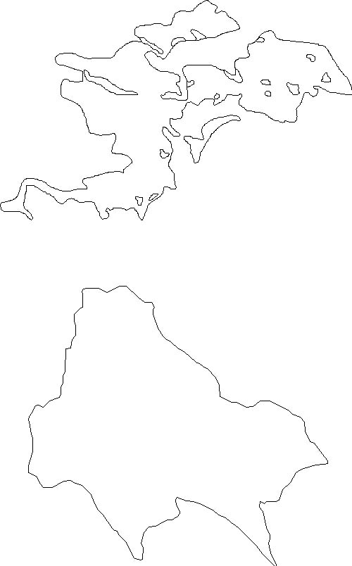
the shape of the opening. The natural and harvest openings depicted in
Figure 1 are almost the same size ,328 ha and 318 ha respectively for the
natural and harvest opening, but the perimeter (i.e., edge) of the natural
opening is more than twice as long (26 715 m vs 10 111 m) as the simpler
harvest opening. There are various methods of estimating shape complexity.
One such measure is the shape index (Patton 1975) which is calculated
using the following formula:
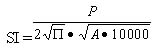
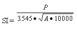
or simplified as: where SI = shape index, P = perimeter (m), A = area
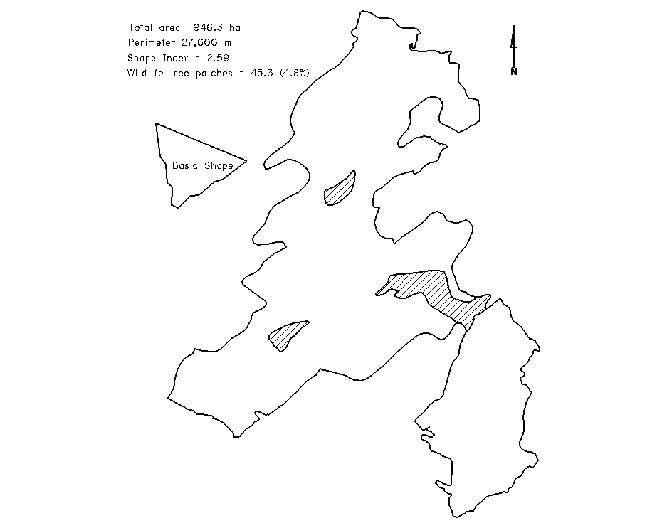
(ha) < /SPAN > Riparian reserve edges and younger forest are obvious features which can be used to make the shape of an opening more complex. Others include non-forested units where no riparian reserve is required (e.g., avalanche tracks or alder swales), stands with low commercial value such as stands on rock outcrops or at high elevation, and stands of species not being utilized in the intended harvest (e.g., deciduous species). Many of these types of natural boundaries are also relatively windfirm (see Stathers et. al. 1994). To be practical, the majority of the boundaries chosen should be easy to locate on the ground. However, allowing some discrepancies between planned and final boundaries and utilizing global positioning systems (GPS) reduces the importance of this consideration. In future, fire spread models could be adapted in order to assist in opening design (e.g., Andison 1996). Andison's model already allows the user to specify a location and block size and using fire spread attributes (e.g., forest cover, topography), available in a GIS, design an opening which has the characteristics of a wildfire opening. The model also allows limits to be set with respect to forest age boundaries that the opening is not allowed to transcend (i.e., < age class 6). Once boundaries of an opening are finalized, edge feathering could be used during harvesting to increase the effective edge of the opening. Feathering along older multi-storied stand edges may also reduce blowdown (Stathers et al. 1994). One of the benefits of "mimicking natural disturbance" rather than defaulting to a maximum block size is the ability to harvest to windfirm boundaries. Thus, design of edges to reduce windthrow is an important consideration. A detailed examination of factors to consider to reduce windthrow can be found in the "Windthrow Handbook for British Columbia Forests" (Stathers et al. 1994). The basic design of the block should attempt to reduce fetch to non windfirm boundaries. Recent data from the Opax Silviculture Systems trials near Kamloops and data from a study of windthrow in wildlife tree patches (DeLong unpublished data) indicate that windthrow increases significantly where the fetch is >150m in the direction of prevailing winds. A basic block shape which should reduce windthrow resembles a silhouette of the crown of a spruce tree (Figure 2). The wide base of this shape should be anchored at the windward end of the block by a windfirm edge and stepped down into the main direction of wind (e.g., SW to NE). Table 2 highlights some important things to consider when choosing windfirm edges.
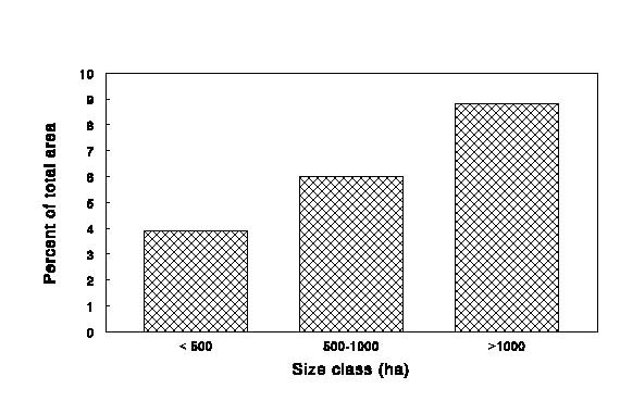
Patches of mature trees left in an opening are likely important for the reestablishment or maintenance of a variety of organisms. The usefulness of island remnants as wildlife habitat was demonstrated by Gasaway and DuBois (1985) in a study of the ecological impacts of large fires on moose. They found that 67% of the moose observed within a fire perimeter were located in unburned islands which covered only 15% of the total fire area. Bird studies comparing a clearcut without patches, a clearcut with patches, and uncut forest found that relative abundance was highest in patches within the clearcut and that some species such as woodpeckers and nuthatches were found in the clearcut with patches but not the clearcut without patches (Gyug, unpublished data). A recent study by Seip (1997) also concluded that leaving wildlife tree patches within clearcuts benefits many forest bird species. Island remnants may also act as biological refugia for certain organisms. Hypogeous fungi have been demonstrated to be more abundant in remnant Douglas-fir stands than in the surrounding young forest (Ammaranthus 1994). Guidance for leaving wildlife tree patches is provided in the Biodiversity Guidebook. The discussion contained here will be based on studies of 'island remnants' left in wildfires (DeLong and Tanner 1996) and will use this as a basis for providing recommendations as to the size class distribution and landscape placement of wildlife tree patches. It is important that all landscape positions be represented when designing wildlife tree patches. Current research on bird use of remnants indicates that lodgepole pine trees are the preferred nesting site for some woodpeckers (Ken Parker, pers. comm. 1997). This would argue against having most of the wildlife tree patch requirement made up of riparian or wetland areas which tend to be dominated by hybrid white spruce or black spruce. In addition, the study conducted by DeLong and Tanner (1996) found that wildfire remnants were as common on flat sites dominated by lodgepole pine as any other landscape position. Two other relationships, from the studies of Eberhardt and Woodward (1987) and DeLong and Tanner (1996), relate to amount and size of remnants. As wildfire size increases so does the proportional area and maximum size of remnants (Figure 3 & Table 3). It would seem ecologically prudent to increase the proportional amount of wildlife tree patch area when designing larger (i.e., > 500 ha) openings. Table 3 shows the distribution of sizes of remnants within different size class wildfires. In wildfires < 1000 ha all remnants are less than 10 ha and about half of them are 2 ha or less. In wildfires > 1000 ha remnants may be over 50 ha in size and only 20% are 2 ha or less. Larger reserves (i.e., > 10 ha) should be a consideration if designing blocks greater that 500 ha. If such a block involves cutting reserves between previously harvested blocks larger reserves could be left along previously harvested block edges that have demonstrated windfirmness. The effects of wildfire on remnants are variable. Some remnants completely escape burning while in others light under burning consumes a portion of the humus layer and scars trees but leaves most trees intact. In some, mainly those dominated by Douglas-fir, many of the trees have been killed leaving only scattered survivors. These variable effects can also be achieved within wildlife tree patches by adopting variable retention strategies. This could be particularly effective in stands dominated by Douglas-fir which are conducive to various partial cutting techniques. If partial cutting is done it is important to ensure care is taken to reduce damage to the root systems of leave trees by logging on a snow pack or restricting traffic around and within the partially harvested area. No mechanical site preparation should occur within these areas, however broadcast burning may be an option if Douglas-fir is the leave species. Under guidelines outlined in the Biodiversity Guidebook, the area that will be applied to wildlife tree patch requirements can be calculated using the formula: AWT = BAR/BAT * AP where AWT = area applied to
wildlife tree patch requirement, BAR = basal area retained, BAT = total
basal area of patch prior to harvest, and AP = area of
patch. Windfirmness is an obvious consideration in the design and placement of wildlife tree patches. The same factors which are used to choose windfirm edges can be used to select the most windfirm remnants (Table 2). In addition, some previous work by Steventon et al. (unpublished data) indicates that circular shapes are best. Other work done by DeLong (unpublished data, FRBC Project OP96060-RE ) indicates that windthrow may be reduced by:�
� designing reserves larger
than 5 ha, �
� not locating reserves in
crest and lower to toe slope positions, and �
� orienting the long axis of
oblong shaped remnants SW to NE (i.e., in the direction of major winds).
If other considerations
dictate that reserves be less than 5 ha then windthrow may be reduced
by: �
� choosing reserves on sites
where the combined depth of humus and organic soil is less than 7
cm, �
� choosing reserves on sties
where effective rooting depth is >15 cm, and �
� locating reserves less than
150m from the opening edge in the direction of prevailing
winds. HARVESTING Although this workbook is intended to cover the design aspects of natural disturbance blocks the harvesting phase is critical to achieving overall objectives. Logging should generally progress from an identified windfirm boundary into the direction of major winds (i.e., from NE to SW). When large openings are being harvested over a number of years, non windfirm portions should be logged as early as possible. If low to moderate levels of windthrow occur the edge should be left. However, if high levels of windthrow do occur, the boundaries could be adjusted so that the edge can be cleaned up and brought to a more windfirm position before the opening is completed. This may necessitate adjustments on other boundaries in order to meet the target block size. Feathering, topping and pruning could also be used along non windfirm edges. This may help buffer the edge just as snags left by wildfire appear to buffer wildfire edges. Low ground pressure equipment should always be utilized during the harvesting of non windfirm edges to reduce impact on the supporting roots of the leave trees. Other windthrow management techniques are discussed in Chapter 6 of Stathers et. al. (1994) and this reference should be used when developing the harvesting prescription.
�
� choose a group of recent
blocks as older blocks (i.e., > 15 years old ) have already imprinted
themselves on the landscape �
� choose blocks in close
proximity to one another (i.e., 500-2000m) �
� aggregate blocks such that
long axis is aligned with major winds (i.e., SW to NE) �
� locate a potential anchor
block at windward end with known windfirm edge (i.e., block > 3 years
old with negligible windthrow) �
� attempt to follow natural
boundaries such as young forest edge, wetland complexes, riparian areas
and avalanche tracks �
� use windfirm edge criteria
to choose other boundaries (Table 2) �
� create shape that will
reduce fetch to non-windfirm edges (e.g., Figure 2) �
� using relative winfirmness
criteria adjust and refine edges �
� make any straight edges more
irregular while avoiding formation of non windfirm
peninsulas �
� finalize map of block and
generate area and perimeter �
� ensure area is under maximum
area specified and shape index is within suggested limits (Table
1) �
� adjust boundaries as
required �
� map out on air photos or
detailed map �
� calculate
areas �
� calculate area required
beyond reserves �
� determine approximate
location to meet distance to cover guidelines �
� calculate mean size based on
area and total number required �
� map outline on air photos
taking into consideration goals of ecosystem representation, windfirmness,
and variability in size �
� assign no harvest or partial
harvest to each �
� recalculate area based on
reduction for any partial harvest reserves �
� outline general area where
smaller reserve should be � � provide some guidance to operator as to desired characteristics of reserve
REFERENCES Table 1. Recommended shape index for different
size openings.
Table 2. Windthrow hazard evaluation using
identifiable features from maps,
air photos and field reconnaissance.
Table 3 Average and range in proportion of area of island remnants by size class of remnant for wildfires < 1000 ha and > 1000 ha.
Figure 1. Comparison of wildfire (top) with harvest block showing difference in shape.
Figure 2. Map of amalgamated block showing application of basic windfirm shape. Hatched areas are large wildlife tree patches.
Figure 3.
Percent of total area of wildfire occupied by island remnants by
size class of wildfire.
|
|||||||||||||||||||||||||||||||||||||||||||||||||||||||||||||||||||||||||||||||
|
|
||||||||||||||||||||||||||||||||||||||||||||||||||||||||||||||||||||||||||||||||