Fort St. John Pilot Project
|
|
Fort St. John Pilot Project |
|
| |||||||||||||||||||||||||||||||||||||||||||||||||||||||||||||||||||||||||||||||||||||||||||||||||||||||||||||||||||||||||||||||||||||||||||||||||||||||||||||||||||||||||||||||||||||||||||||||||||||||||||||||||||||||||||||||||||||||||||||||||||||||||||||||||||||||||||||||||||||||||||||||||||||||||||||||||||||||||||||||||||||||||||||||||||||||||||||||||||||||||||||||||||||||||||||||||||||||||||||||||||||||||||||||||||||||||||||||||||||||||||||||||||||||||||||||||||||||||||||||||||||||||||||||||||||||||||||||||||||||||||||||||||||||||||||||||
|
DISTURBANCE UNITS DESCRIPTIONSIntroduction
There has been a steady
increase in the use of our knowledge of natural disturbance dynamics as a
basis for forest management policy directed towards maintaining biological
diversity (Booth et al. 1993, Biodiversity Guidebook… 1995). The
underlying assumption is that the biota of a forest is adapted to the
conditions created by natural disturbances and thus should cope more
easily with the ecological changes associated with forest management
activities if the pattern and structure created resemble those of natural
disturbance (Hunter 1993, Swanson et al. 1993, Bunnell 1995, DeLong and
Tanner 1996, Bergeron and Harvey 1997, Angelstam 1998, DeLong and Kessler
2000). For a variety of reasons,
past forest management policies and guidelines have been directed towards
setting somewhat arbitrary limits. These limits were often related to
maximizing timber volume or creating conditions that favoured certain
organisms (e.g., ungulates). Limits were often stated for things such as
patch size, species composition, stand density, non-forested area and soil
disturbance. Although well meaning and easily administered, these
practices result in patterns bearing little relationship to those created
by natural disturbance dynamics. Studies of natural disturbance in the
boreal forest have demonstrated large ranges in disturbance patch size
(Eberhart and Woodward 1987, DeLong and Tanner 1996), tree density (DeLong
and Kessler 2000), and volume of coarse woody debris (CWD) (Clark et al.
1998, DeLong and Kessler 2000) The Biodiversity Guidebook
(1995) was the first attempt in British Columbia to present guidance for
forest management based on the natural disturbance template. Specific
guidance for seral stage distribution, patch size, wildlife tree patch
amount, and spatial arrangement and more general guidance on species
composition and stand structure were included in this guide. Since the
completion of the Biodiversity Guidebook, more information on natural
disturbance dynamics has become available. Within the Prince George Forest
Region a number of studies have investigated particular aspects of natural
disturbance (e.g., DeLong 1998, DeLong and Kessler 2000, Lewis and
Lindgren 2000, Rogeau 2001). This document is meant to present updated
guidance for the Prince George Forest Region based on this new
information. Unlike the Biodiversity Guidebook, this document presents
goals based on the “range of natural variability” and does not present any
numbers that represent a compromise between biodiversity and timber
management. Thus this document presents guidance based on “the best
available information” that would result in the least possible differences
between harvesting and natural disturbance. Instead of adopting the
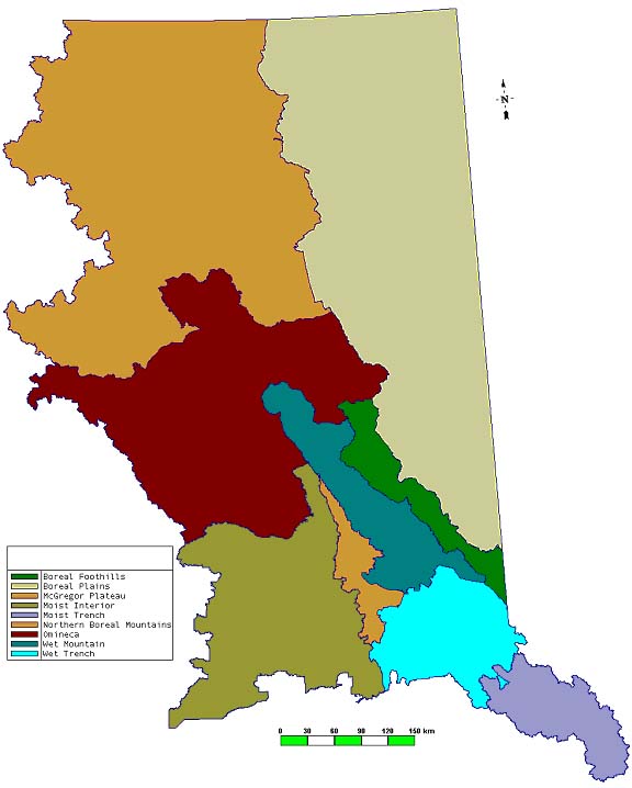
Natural Disturbance Types (NDT’s) presented in the Biodiversity Guidebook
(1995) this document presents information for 9 Natural Disturbance Units
(NDU’s) (Figure 1). These units are felt to better separate areas based on
differences in disturbance processes, stand development, and temporal and
spatial landscape pattern. In the drawing of the boundaries of the NDU’s,
Landscape Unit boundaries were used whenever possible. This avoids the
problem of having very small areas within a planning unit with different
guidance than the rest of the unit.
Figure 1. Natural Disturbance Units of the Prince George Forest Region.
Table 1. List of biogeoclimatic units
within each of the Natural Disturbance Units
1
Units in brackets cover a minor (i.e., <5%) portion of the Natural
Disturbance Unit. Moist Interior
Location, Climate, and Vegetation
This unit occupies the gently rolling terrain and
broad mountain peaks of the Fraser Plateau and the Fraser Basin
Ecoregions. This NDU is found over a wide geographic range, from 53° - 55° N
latitude and 122° - 125° W longitude. The elevation range of this NDU
is 600 – 1800m but most of it is between 700 – 1200m. The climate of this unit is continental, and is
characterized by seasonal extremes of temperature; severe, snowy winters;
relatively warm, moist, and short summers; and moderate annual
precipitation (Meidinger et. al. 1991). Excluding the Boreal Plains, this
is drier than the other NDU’s in the region. It is intermediate in
temperature between the colder montane and northern units, and warmer
trench units. Mean annual temperature (MAT) for moist of this unit ranges
from 0.6 to 3.7°C. Average temperature is below 0°C for 4-5 months of the
year, and above 10°C for 2-5 months. Mean annual precipitation (MAP) data
from long-term stations ranges from 481-727 mm, of which perhaps 25-50% is
snow. Higher elevation mountains in the unit will likely have a more
severe climate (i.e., lower temperatures, more precipitation, more snow)
but no data is available for these areas. Upland coniferous forests dominate the Moist Interior
- Plateau landscape. Hybrid white spruce (Picea engelmannii
x glauca) and subalpine fir are the dominant climax
tree species. Lodgepole pine is very common in mature forests throughout
the unit and both lodgepole pine and trembling aspen pioneer the extensive
seral stands. Paper birch is another pioneer tree, often on moist, rich
sites. Douglas fir is usually a long-lived seral species, occurring most
abundantly on dry and warm sites in the southeastern part of this unit.
Black spruce also occurs in climax upland forest in combination with
lodgepole pine on sites with restricted rooting. Forests at higher
elevations (>1100m) will have a higher subalpine fir component.
Alluvial forests of black cottonwood, often with a
minor component of spruce, occur to a limited extent on active floodplains
of the major streams and rivers. Wetlands are common and dot the landscape
in poorly drained, postglacial depressions or river ox-bows. Wetland community types include Carex (sedge)
marshes, shrub fens of Betula glandulosa (scrub birch), B. pumila
(swamp birch), and Salix spp. (willows), treed fens and swamps with
black and hybrid white spruce, and black spruce — Sphagnum bogs.
Acidic, nutrient-poor bogs are less common than the richer wetland types
(marshes, fens, and swamps). Tamarack occurs in a number of wetlands south
of the Nechako River. Natural grassland and shrub-steppe are uncommon in
this NDU, occurring on some warm, dry sites scattered in the major
valleys. Natural Disturbance Ecology
Fire and
mountain pine beetle (Dendroctonus ponderosae) are the key
stand-replacement disturbance agents operating in this unit. The
disturbance rate[1][1] for the plateau and mountain portions of
this unit are estimated to be 0.75 - 1.25 % [2][2] and 0.48 % of the total forested area/yr
respectively (DeLong 1998). The fire cycles assigned to these unit are 100
and 200 respectively, based on work conducted by Andison (1996) and DeLong
(1988). Table 2 shows the amount of forests of different age that would be
associated with this fire cycle. Large wildfires (> 1,000 ha) dominated
the landscape and were regenerated quickly by dense lodgepole pine and/or
trembling aspen resulting in large patches of relatively even-aged forests
(Table 2). Minor amounts of young white and/or black spruce forest could
be found in wetter patches within the fire boundaries often adjacent to
unburned mature forest not burned by the fire. Young Douglas fir stands
can be found on drier ridges near larger Douglas-fir veterans that have
escaped the fire. Small areas where fire was intense may regenerate to
willow or alder (Delong, unpublished data). Stand ages rarely exceeded 200
years, except in the more mountainous areas, but relatively large patches
(>100 ha) of older forest (140 – 180 yrs) could be found scattered
across the landscape (Andison 1996, DeLong and Tanner 1996). Although
patches of old forest (> 140 yrs) likely always occurred in the
landscape their position would have moved around the landscape over time.
Within the boundaries of the fires 3-15% of total area of the fire can be
composed of unburned mature forest remnants (DeLong and Tanner 1996).
These mature forest remnants are distributed throughout all landscape
positions including flat lodgepole pine stands (DeLong and Tanner 1996).
Very little remnant structure exists outside of these patches. Data from
DeLong and Tanner (1996) indicate that there was <1 live remnant
tree/ha outside of remnant patches. More live remnant trees likely occur
in areas with a higher component of Douglas-fir due to their increased
ability to survive fire, but this has not been tested.
During stand development, increasing amounts of white
spruce, black spruce, and subalpine fir will occur in stands originally
dominated by lodgepole pine or trembling aspen. This increase occurs more
rapidly and these species become a more dominant portion of the canopy on
wetter sites. Douglas fir will be co-dominant where established with
lodgepole pine. Post-fire stands are very dense except on the wettest
sites and then self thin over time (Table 3). Density of snags > 7.5 cm
dbh generally exceeds 100 sph and is highest in mature stands due the
effect of self-thinning (Table 3). Larger diameter trees and snags (>15
cm dbh) are most abundant in stands exceeding 140 yrs of age but do occur
in stands of all ages (Table 3). Coarse woody debris (CWD) volume ranges considerably
in response to the time since the last fire, age of the stand at time of
the fire, and number of times it has burned (Table 4). Fires may burn over
the same area 2 –3 times within a short period of time (<50 yrs)
leaving very little dead wood on the ground. CWD volumes are highest in
young stands due to large amount of wood that is left over from the
previous stand (Table 3). Very little of the main stem wood of mature live
trees is actually consumed by fire and
Table 2. Estimates of statistics relating to temporal
and spatial pattern of natural disturbance in the Natural Disturbance
Units of the Prince George Forest Region.
Table 3. Means and
standard deviations of selected stand characteristics for young matrix
forest (40 – 70 yrs old), mature matrix forest (70 –140 yrs old), remnant
patches and old matrix forest (> 140 yrs old) for mesic sites within
the SBSmk1 (adapted from DeLong and Kessler 2000).
Table 4. Summary
statistics for CWD volume for young matrix, mature matrix, remnant
patch, and old matrix forest categories. (n = 10) (from
DeLong and Kessler 2000).
standing snags are mostly down after 40 years, thus
most of the standing live tree biomass ends up as CWD. Forest Management Effects Fire control and harvesting pattern are likely the 2
factors most affecting the natural landscape pattern and processes in this
NDU. Effective fire control over the past 40 - 50 yrs has
slowed the natural disturbance rate from 0.8 to 0.008% of the total
forested area/yr. This has had the compound effect of increasing the
amount of old forest in more remote areas where harvesting was not
occurring (e.g., south end of Vanderhoof District) and reducing young
forest established by fire. Increasing old forest that is the most
susceptible to MPB and decreasing the amount of large patches of young
forest that is least susceptible to MPB in some remote areas has likely
exacerbated the current MPB infestation. Some organisms appear to be heavily dependent on fire
killed forests. Hutto (1995), in a study of bird communities following
stand-replacement fires in the Rocky Mountains of Montana, found that
black-backed woodpeckers (Picoides arcticus) were generally restricted in
their habitat distribution to standing dead forests created by
stand-replacement fires. Four talks at the recent “Disturbance
Dynamics In Boreal Forests” conference in Finland dealt with fungi and
insects that were either fire obligates or heavily favoured by fire. These organisms require
the burned dead trees found after fire and occur at much reduced numbers
after forest salvage operations (Stepnisky, unpublished data).
While wildfire creates disturbances of all sizes and
the landscape is dominated by large disturbances, forest management has
generally been directed to achieve mid-sized patches (40 – 100 ha) (DeLong
and Tanner 1996). Larger harvest patches often occur due to management of
beetle or windthrow. Dispersed harvest of mid-sized patches is both very
unnatural but also creates fragmentation and a porous landscape for spread
of pests such as MPB. Currently, disturbance rates associated with
harvesting are similar to those previously associated with wildfire.
However, harvesting removes old forest at a faster rate then wildfire
because harvesting concentrates on stands > 100 years of age whereas
wildfire is relatively unselective as to the age of stand it will burn
(Van Wagner 1978, Johnson 1992). Dense stands of lodgepole pine
were typical after wildfire. The lowest stocking level found for young
natural stands (50 yrs old) on in the SBSmk1 was 2224 sph > 7.5 dbh
(Table 3) (DeLong 1998). Managed stands vary considerably in density
depending on whether natural or artificial regeneration is used and the
rate of ingress from naturally regenerated stems. MoF records for young
managed stands in the SBSmk1 indicate stocking levels of 500 - 21 000 sph
(average 3475 sph). Certain practices such as low impact site preparation,
which limits mineral soil exposure, in combination with modest stocking
levels (<1600 sph) may result in some stands being outside the natural
range of variability in stocking level but this remains to be examined.
Recommended
Practices
Old forest Since forests with “old forest characteristics”, on
the plateau portion of this NDU, typically ranged from 120 – 200 years, it
seems appropriate to have a system of rotating old forest reserves between
these ages. This would insure stands with “old forest characteristics”
exist but they are not unnaturally old and more susceptible to pest
infestation.
Large patches (> 100 ha) of old forest should be identified and
recruited such that replacement areas > 120 years old are available to
replace areas > 150 years of age that would be harvested. Recruitment
areas should be preferentially selected in the following order: 1)
unsalvaged wildfires, 2) partially salvaged wildfires, 3) large blocks
designed to approximate wildfire that have mostly been regenerated
naturally, 4) large blocks (> 100 ha) designed to approximate wildfire
that have mostly been regenerated artificially, 5) large blocks (> 100
ha) that were not designed specifically to approximate wildfire and 6)
small to medium sized blocks (< 100 ha). Fixed reserves may be more
appropriate in the mountain portions of the NDU but may be augmented with
some level of floating reserve. Table 2 contains estimates of seral stage
distribution based on the natural range of variability. Young natural forest
Some proportion of wildfires should be left unsalvaged
to provide habitat (e.g., burned snags) that cannot be provided by young
managed stands. Patch size
Since medium sized patches (50 – 100 ha) are rare in
the natural landscape and small patches are still naturally created by
small fires, windthrow, root disease the emphasis should be on creating
larger patches (> 100 ha). Larger patches should be created by
aggregating recent blocks in areas previously harvested and/or by
designing new large blocks in unharvested areas. Patch size distribution
should follow that of wildfire shown in Table 2as closely as possible
given social, logistic, or demonstrated ecological constraints. Design of
blocks should follow guidance provided in DeLong (2000). Stocking and stand structure
Stand density in young circumesic stands (< 40 yrs
old) should generally kept at total stocking levels of > 2000 sph to
approximate dense natural stands. More open patchy stocking (i.e., <
1000 sph) on hygric sites are recommended. Even-aged stands over most of
the landscape would approximate the natural pattern.
Wet Mountain
Location, Climate, and Vegetation
This unit occupies the valleys and slopes of the Rocky
Mountains west of the continental divide and between 54° - 56° N
latitude. The climate of this unit is continental, and is
characterized by seasonal extremes of temperature; severe, very snowy
winters; and cool, very wet, and short summers. This is the wettest of the
NDU’s in the region. The temperature regime varies in a gradient from
valley to mountain top. MAT of the lower elevation SBSvk is 2.6°C and
0.3°C for the higher elevation ESSFwk2. MAP data from long-term stations
is 1250 and 1537mm respectively for the SBSvk and ESSFwk2. Annual snowfall
often reaches 6 to 9 m depending on elevation. Old upland coniferous forests dominate the Wet
Mountain natural landscape. Hybrid white spruce and subalpine fir are the
dominant climax tree species. Lodgepole pine is limited to some wetlands
and Douglas-fir to a few dry rocky ridges. Paper birch occurs as a pioneer
tree in scattered recently disturbed areas. Some cottonwood occurs along
the floodplains of the larger rivers. Black spruce occurs in wetlands that
occupy some of the broader valley bottoms. Sitka alder (Alnus viridis
ssp. sinuata) occurs commonly on slopes throughout the
unit on avalanche tracks and in swales. Natural Disturbance Ecology
Stand-replacement disturbance events occur at
irregular intervals with as much as 1000 years between such events on any
site. The stand replacement disturbance rate[3][3] for this unit is estimated to be only 0.1 %
[4][4] of the total forested area/yr (DeLong
1998). The stand replacement disturbance cycle assigned to this unit is
900, based on work conducted by Hawkes et. al. and DeLong (1988). Table 2
shows the amount of forests of different age classes that would be
associated with this disturbance cycle. Fire sizes are generally smaller
than for other NDU’s with only 10% of the total area in patches > 1000
ha but there is still 60% in the 100 – 1000 ha patch size (Table 2).
In the absence of stand replacement disturbance,
stands are affected by damaging agents that operate in older stands, so
called matrix disturbance agents (Lewis and Lindgren 2000). The agents
most commonly associated with older trees in this NDU are spruce beetle
(Dendroctonus
ponderosae), western balsam bark beetle (Dryocoetes
confusus), tomentosus root disease (Inonotus
tomentosus), and stem decays such as Indian paint fungus (Echinodontium
tinctorium). These agents alter stand species composition and
horizontal and vertical structure by causing tree mortality either on
their own or in combination with other damaging agents (e.g., wind,
disease). Spruce beetle may cause severe mortality at regular intervals
leading to a shift in species composition to subalpine fir and release of
suppressed trees (Lewis and Lindgren 2000). In the absence of lodgepole
pine over most of this unit, stands attain stocking slowly even after
wildfire resulting in open multi-aged early to mid successional stands
(DeLong et al. 1998). The long stand replacement disturbance rate,
damaging agents causing selective mortality and slow regeneration result
in open multi-aged stands dominating the landscape. Natural stands, of any age, generally do not exceed
1000 sph > 7.5 cm dbh and density of the main canopy is generally <
400 sph (DeLong et al. 1998) (Table 5). Spruce tends to out live subalpine
fir in this unit so they comprise the majority of the largest stems in
older stands. Subalpine fir is more abundant as elevation increases due to
their greater ability to survive in the severe high elevation environment.
Density of snags > 7.5 cm dbh is highest in young (<70 yrs old)
stands and generally exceeds 80 sph in most stands (Table 5). The number
of snags increases with elevation such that stands in the ESSFwk2/wc3 have
almost twice as many snags as equivalent stands in the SBSvk (Table 5).
Coarse woody debris (CWD) volumes show little
variation with stand age but decreases with elevation in correspondence to
decreases in live tree volume (DeLong et al. 1998). Average CWD volume is
generally 150 – 250 m3/ha for stands in the SBSvk and
100 – 200 m3/ha for stands in the
ESSFwk2/wc3 (DeLong et al. 1998). Arboreal lichen abundance is high in older forests
especially in the ESSFwk2/wc3. Although young stands (<70 yrs old) have
lower amounts of arboreal lichen there appears to be no clear differences
between mature (70 – 140 yrs) and old (>140 yrs) stands especially
within the ESSFwk2/wc3 (DeLong et al. 1998). Forest Management Effects Harvesting and reforestation practices are likely the
2 factors most affecting the natural landscape pattern, stand composition
and structure and associated processes in this NDU. Clearcut harvesting has been quite extensive in
portions of this NDU resulting in more area in early seral stands and less
area in older forest than would have existed in the natural landscape for
at least the last 500 years. Lodgepole pine has been planted in some areas
within this NDU on sites where there is no present evidence of it having
occurred. Current practices favouring the planting of spruce over
subalpine fir at higher elevations will likely lead to stands with a
higher proportion of spruce in managed stands as compared to natural
stands. Current reforestation standards for stocking will result in stands
being more densely stocked and more even-aged than natural stands. The
potential impacts of the conversion of a landscape dominated by older more
open stands to a landscape with a high proportion of denser younger
even-aged stands are uncertain. Lewis and Lindgren (2000) hyphothesize
that a transition to more homogenous stands could result in significant
pest outbreaks, specifically of white pine weevil (Pissodes
strobi) and tomentosus root rot.
Table 5. Mean values and
standard deviation (in brackets) for selected stand characteristics in
young (0-70 yrs), mature (71-140 yrs) and old (>140 yrs) stands for the
SBSvk and ESSFwk2/wc3 (n=4 for SBSvk, n=5 for ESSFwk2/wc3 except where
noted) (Adapted from DeLong et al. 1998).
1 only 1 plot had trees with >7.5cm dbh. 2 based on 4 plots, for 3 of the plots trees over 7.5cm
dbh were from the pre-disturbance cohort.
Recommended Practices
Old forest Since forests with “old forest characteristics”
dominated the landscape in this NDU, it seems appropriate to have old
forest reserves or forest > 100 yrs old well distributed throughout all
watersheds. A high degree of connectivity between these old forest patches
should also be managed for since there was always a high degree of
connectivity of old forest in the natural landscape. Since differences
between mature and old forests appear to be limited based on available
data some flexibility in the current age criterion for “old growth forest”
should be considered. Table 2 contains estimates of seral stage
distribution based on the natural range of variability. Young natural forest
Some proportion of areas disturbed by natural
disturbance agents (e.g., wildfires, pests, wind) should be left
unsalvaged to provide habitat (e.g., burned snags) that cannot be provided
by young managed stands. Patch size
The patch size for clearcut harvesting should follow
that of wildfire shown in Table 2as closely as possible given social,
logistic, or demonstrated ecological constraints. Design of blocks should
follow guidance provided in DeLong (2000). Silviculture system
Some form of partial cutting that approximate the
effects of spruce beetle attack would seem appropriate in order to
maintain the type of stand structure most common in the natural landscape.
Some balance between this system and clearcut with reserves would seem
most appropriate. Stocking and stand structure
Appropriate measures need to be developed to achieve
open patchy multi-storied stands over most of the landscape.
Boreal Plains Location, Climate, and Vegetation
This unit occupies the gently rolling terrain of the
Taiga Plains and Boreal Plains Ecoprovinces. This NDU is found over a wide
geographic range, from 54° - 60° N latitude and 119° - 123° W
longitude. The unit generally occurs from the valley bottoms to 900 - 1100
m elevation, below the Boreal Foothills NDU in the south and Northern
Rockies NDU in the north. The northern continental climate of this unit is
characterized by frequent outbreaks of arctic air masses resulting in
long, very cold winters and short summers. However due to long day length
in the summer forest productivity is similar to areas further south. This
is driest NDU in the region, with MAP ranging from 330 – 570mm, with
35-55% falling as snow. It is the coldest lower elevation NDU. MAT ranges
from –2.9 to 2.0°C. The ground freezes for a large part of the year, and
discontinuous permafrost is common in the northeastern parts of this
NDU. Upland climax forests are dominated by hybrid white
spruce and/or black spruce depending on topographic position and time
since last stand replacement disturbance. It is theorized that in the
absence of a stand replacement event, stand productivity will drop and
proportion of black spruce will increase in response to reductions in soil
temperatures and nutrient cycling due to the build-up of the forest floor.
Trembling aspen and to a lesser extent lodgepole pine and paper birch
dominate young stands. Mixed forests of trembling aspen and white spruce
are very common except in areas where the spruce seed source has been
removed due to land clearing. Wetlands are very common and diverse especially in the
northern portion of this NDU. There are 7 forested and 9 non-forested
wetland types recognized within this NDU. Black spruce or tamarack
dominates the forested wetlands. Non-forested wetlands are most commonly
dominated by speckled alder, swamp birch, Alaska paper birch (Betula
neoalaskana), willows, sedges, or buckbean (Menyanthes
trifoliata). Alluvial forests of black cottonwood, often with a
minor component of spruce, are common along the floodplains of the larger
rivers. Natural grassland and shrub-steppe occur on steep, south-facing
slopes above some of the major rivers such as the Peace. Natural Disturbance Ecology
Fire is the key
stand-replacement disturbance agent operating in this unit with the
exception of the broad alluvial terraces adjacent to the larger rivers.
The disturbance rate[5][5] for the non-alluvial portions of this unit
is estimated to be about 1% [6][6] of the total forested area/yr and has been
assigned a fire cycle of 100 years. Table 2 shows the amount of forests of
different age that would be associated with this fire cycle. Large
wildfires (> 1,000 ha) dominated the landscape and upland sites were
regenerated quickly by dense trembling aspen, trembling aspen and spruce
or lodgepole pine resulting in large patches of relatively even-aged
forests (Table 2). Black spruce, tamarack, Alaska paper birch and white
spruce regenerated the wetland areas after fire. These stands tend to be
very open and fill in over time except where they are verging on upland
areas, in which case they can be denser. Small areas where fire was
intense may regenerate to willow or alder (DeLong, unpublished data).
Tomentosus root disease is felt to be a key disturbance agent affecting
white spruce and in some localized areas may cause conversion from spruce
dominated stands to aspen dominated stands over the course of 20-40 years
(pers. comm. Richard Reich, Prince George MoF, Regional Pathologist).
Eastern spruce budworm (Choristoneura fumiferana) may also cause
significant mortality of mature or immature spruce and lead to conversion
of mixed to more pure aspen stands. Stand ages rarely exceeded 200 years
but relatively large patches (>100 ha) of older forest (140 – 180 yrs)
could be found scattered across the landscape (Don Rosen, unpublished
data??). Although patches of old forest (> 140 yrs) likely always
occurred in the landscape their position would have moved around the
landscape over time. Within the boundaries of the fires 3-15% of total
area of the fire can be composed of unburned mature forest remnants
(Eberhart and Woodward 1987). During stand development, increasing amounts of white
spruce and black spruce will occur in stands originally dominated by
trembling aspen or lodgepole pine. This increase occurs more rapidly and
these species become a more dominant portion of the canopy on wetter
sites. Post-fire stands are very dense except on the wettest sites and
they self thin over time. Density of snags for aspen mixedwood stands is
likely similar to that reported in Lee et al. (1995). They report snag
densities (±S.E.M.) of 33.0±6.8,
73.1±11.3,
and 66.2±9.1
snags/ha (ł10 cm dbh) for young (20-30 years), mature (50-65
years) and old (120+ years) stands, respectively. CWD
volumes of aspen mixedwood stands are likely similar to that reported in
Lee et al. (1995). They report total CWD volumes (±S.E.M.) of 108.8±5.1,
109.1±7.6,
and 124.3±7.1 m3/ha for young
(20-30 years), mature (50-65 years) and old (120+ years) stands,
respectively. There is a lack of information on disturbance cycles
and patch sizes with respect to flooding along the major rivers in this
NDU. We have temporarily assigned a stand replacement disturbance cycle of
200 years to the alluvial portions of this NDU (Table 2). Disturbance
patches are thought to be < 100 ha in size (Table 2). There is a
typical flood plain succession from willow to cottonwood on the lower
benches and from cottonwood to spruce on the higher benches. Forest Management Effects Fire control and harvesting pattern are likely the 2
factors most affecting the natural landscape pattern and processes in this
NDU. Effective fire control over the past 40 - 50 yrs has
slowed the natural disturbance rate (ANY DATA??). This has had the
compound effect of increasing the amount of old forest in more remote
areas where harvesting has not occurred and reducing young forest
established by fire. Some organisms appear to be heavily dependent on fire
killed forests. Hutto (1995), in a study of bird communities following
stand-replacement fires in the Rocky Mountains of Montana, found that
black-backed woodpeckers (Picoides arcticus) were generally restricted in
their habitat distribution to standing dead forests created by
stand-replacement fires. Four talks at the recent “Disturbance Dynamics In
Boreal Forests” conference in Finland dealt with fungi and insects that
were either fire obligates or heavily favoured by fire. These organisms require
the burned dead trees found after fire and occur at much reduced numbers
after forest salvage operations (Stepnisky, unpublished data).
While wildfire creates disturbances of all sizes and
the landscape is dominated by large disturbances, forest management has
generally been directed to achieve mid-sized patches (40 – 100 ha) (DeLong
and Tanner 1996). Larger harvest patches often occur due to management of
windthrow. Dispersed harvest of mid-sized patches is both very unnatural
but also creates fragmentation and a porous landscape for spread of pests
that attack older trees. Land clearing for agriculture, range, and forestry
have removed mature spruce forest from many areas resulting in a loss of
natural spruce regeneration. This along with silvicultural practices aimed
at regenerating spruce or aspen, but not both, has lead to a shift in
natural tree species distribution patterns. Well site clearing and clearing of seismic lines
associated with the oil and gas industry has resulted in fragmentation of
the landscape and human access into remote areas of this NDU. Concentrated harvesting along the alluvial benches of
the major rivers has almost certainly reduced the amount of old forest in
these areas.
Recommended
Practices
Old forest Since forests with “old forest characteristics”
typically ranged from 120 – 200 years in this NDU, it seems appropriate to
have a system of rotating old forest reserves between these ages. This
would insure stands with “old forest characteristics” exist but they are
not unnaturally old and more susceptible to pest infestation. Large patches
(> 100 ha) of old forest should be identified and recruited such that
replacement areas > 120 years old are available to replace areas >
150 years of age that would be harvested. Recruitment areas should be
preferentially selected in the following order: 1) unsalvaged natural
disturbances, 2) partially salvaged natural disturbances, 3) large blocks
designed to approximate wildfire that have mostly been regenerated
naturally, 4) large blocks (> 100 ha) designed to approximate wildfire
that have mostly been regenerated artificially, 5) large blocks (> 100
ha) that were not designed specifically to approximate wildfire and 6)
small to medium sized blocks (< 100 ha). Table 2 contains estimates of
seral stage distribution based on the natural range of
variability. Young natural forest
Some proportion of natural disturbances should be left
unsalvaged to provide habitat (e.g., burned snags) that cannot be provided
by young managed stands. Patch size
Since medium sized patches (50 – 100 ha) are rare in
the natural landscape and small patches are still naturally created by
small fires, windthrow, and root disease, the emphasis should be on
creating larger patches (> 100 ha). Larger patches should be created by
aggregating recent blocks in areas previously harvested and/or by
designing new large blocks in unharvested areas. Patch size distribution
should emulate that of wildfire (Table 2) as closely as possible given
social, logistic, or demonstrated ecological constraints. Design of blocks
should follow guidance provided in DeLong (2000). Stocking and stand structure
Stand density in young circumesic stands (< 40 yrs
old) should generally be kept at total stocking levels of > 2000 sph to
approximate dense natural stands. More open patchy stocking (i.e., <
1000 sph) on hygric sites are recommended. Even-aged stands over most of
the landscape would approximate the natural pattern. In areas of mixed
aspen and spruce efforts should be made to grow mixed stands similar to
those that would have developed under a natural fire regime.
Boreal Foothills Location, Climate, and Vegetation
This unit occupies the valleys and mountain slopes on
the lee side of the Rocky Mountains in the Hart Foothills and Peace
Foothills Ecosections. This NDU occurs in a relatively narrow band, from
54° - 56° N
latitude. The unit occurs from the valley bottoms to alpine peaks, above
the Boreal Plains NDU to the east and adjacent to the Wet Mountain NDU to
the west. The climate of this unit is characterized by frequent
outbreaks of arctic air masses resulting in long, cold, snowy winters and
short summers. This unit is intermediate in precipitation, but one of the
coldest NDU’s. MAP ranges from 560 – 780mm MAT from –0.3 to 0.4°C.
Upland climax forests are dominated by hybrid white
spruce and/or subalpine fir. Subalpine fir increases with elevation.
Lodgepole pine and to a lesser extent trembling aspen and paper birch
dominate young stands. Black spruce occurs sporadically along with
lodgepole pine on upland sites. Wetlands are uncommon but do occur scattered along the
broader valleys and in flatter terrain in the mountains. Alluvial forests of black cottonwood, often with a
minor component of spruce, are found sporadically along the floodplains of
the larger rivers. Natural Disturbance Ecology
Fire is the key stand-replacement disturbance agent
operating in this unit. The fire cycle assigned to this unit is 120 and
150 respectively for the valley (BWBSmw1, SBSwk2) and mountain (BWBSdk1,
ESSFmv2) portions. Table 2 shows the amount of forests of different age
that would be associated with these fire cycles. Large wildfires (>
1,000 ha) dominated the landscape and on upland sites were generally
regenerated quickly by dense lodgepole pine resulting in large patches of
relatively even-aged forests (Table 2). Black spruce and white spruce
regenerated the wetland areas after fire. Stand ages occasionally exceed
200 years and relatively large patches (>100 ha) of older forest (120 –
180 yrs) could be found scattered across the landscape (Don Rosen,
unpublished data). Although patches of old forest (> 140 yrs) likely
always occurred in the landscape at any one time period old forest may be
rare in any particular watershed. During stand development, increasing amounts of white
spruce and subalpine fir will occur in stands originally dominated by
lodgepole pine. This increase occurs more rapidly and these species become
a more dominant portion of the canopy on wetter sites and at higher
elevations. Post-fire stands are very dense except on the wettest sites
and they self thin over time. No data for snags and CWD is currently
available for this unit. Forest Management Effects Fire control and harvesting pattern are likely the 2
factors most affecting the natural landscape pattern and processes in this
NDU. Effective fire control over the past 40 - 50 yrs has
slowed the natural disturbance rate (ANY DATA TO SUGGEST THIS??). This has
had the compound effect of increasing the amount of old forest in more
remote areas where harvesting has not occurred and reducing young forest
established by fire. Some organisms appear to be heavily dependent on fire
killed forests. Hutto (1995), in a study of bird communities following
stand-replacement fires in the Rocky Mountains of Montana, found that
black-backed woodpeckers (Picoides arcticus) were generally restricted in
their habitat distribution to standing dead forests created by
stand-replacement fires. Four talks at the recent “Disturbance Dynamics In
Boreal Forests” conference in Finland dealt with fungi and insects that
were either fire obligates or heavily favoured by fire. These organisms require
the burned dead trees found after fire and occur at much reduced numbers
after forest salvage operations (Stepnisky, unpublished data).
While wildfire creates disturbances of all sizes and
the landscape is dominated by large disturbances, forest management has
generally been directed to achieve mid-sized patches (40 – 100 ha) (DeLong
and Tanner 1996). Larger harvest patches often occur due to management of
windthrow. Dispersed harvest of mid-sized patches is both unnatural but
also creates fragmentation and a porous landscape for spread of pests that
attack older trees.
Recommended
Practices
Old forest Since forests with “old forest characteristics” were
typically dispersed unevenly across the NDU (i.e., rare in some watersheds
but abundant in others) it seems appropriate that old forest targets could
be met over multiple watersheds rather than in each watershed. Table 2
contains estimates of seral stage distribution based on the natural range
of variability. Young natural forest
Some proportion of natural disturbances should be left
unsalvaged to provide habitat (e.g., burned snags) that cannot be provided
by young managed stands. Patch size
Since medium sized patches (50 – 100 ha) are rare in
the natural landscape and small patches are still naturally created by
small fires, windthrow, and root disease, the emphasis should be on
creating larger patches (> 100 ha). Larger patches should be created by
aggregating recent blocks in areas previously harvested and/or by
designing new large blocks in unharvested areas. Patch size distribution
should emulate that of wildfire (Table 2) as closely as possible given
social, logistic, or demonstrated ecological constraints. Design of blocks
should follow guidance provided in DeLong (2000). Stocking and stand structure
Stand density in young circumesic stands (< 40 yrs
old) should generally be kept at total stocking levels of > 2000 sph to
approximate dense natural stands. More open patchy stocking (i.e., <
1000 sph) on hygric sites are recommended. Even-aged stands over most of
the landscape would approximate the natural pattern. In areas of mixed
aspen and spruce efforts should be made to grow mixed stands similar to
those that would have developed under a natural fire regime.
Wet Trench
Location, Climate, and Vegetation
This unit occupies the Rocky Mountain Trench from
approximately Purden Lake to McBride and valleys and slopes of the Rocky
Mountains east to the Continental Divide, and Caribou Mountains to their
western extent. Cool very snowy winters; and warm and very wet summers
characterize the climate of this unit. This NDU is second to the Wet
Mountain NDU in terms of annual precipitation. The temperature regime
varies in a gradient from valley to mountain top. MAT of the lower
elevation ICH is 3.3 – 4.8°C and –0.1 - 0.3°C for the higher elevation
ESSF. MAP data from long-term stations is 840 for the ICH and 1044 -
1537mm for the ESSF. Annual snowfall often reaches 4 to 8 m depending on
elevation. Old upland coniferous forests dominate the Wet Trench
natural landscape. Hybrid white spruce and subalpine fir are the dominant
climax tree species in cold air drainage areas and at elevations above
about 1200m whereas Western red cedar (Thuja plicata)
and western hemlock (Tsuga heterophylla) are the dominant climax
species on the warmer slopes. Lodgepole pine is limited to some wetlands
and the occasional rocky ridge and Douglas-fir as an sporadic element on
drier sites. Paper birch and aspen occur as pioneer trees in scattered
recently disturbed areas. Some cottonwood occurs along the floodplains of
the larger rivers. Black spruce occurs in wetlands that occupy the broader
valley bottoms. Sitka alder occurs commonly on slopes at higher elevations
throughout the unit, on avalanche tracks and in swales. Natural Disturbance Ecology
Stand-replacement disturbance events occur at
irregular intervals with as much as 1000 years between such events on any
site. The stand replacement disturbance cycle assigned to this unit is 600
for the ICH and 800 for the ESSF. Fire cycle would have likely varied
considerably depending on site conditions. It is felt that some toe slope
sites in the ICH may have not had a stand replacement fire for 1000 years
or more. Western hemlock looper (Lambdina fiscellaria ssp. lugubrosa) can
cause significant tree mortality leading to stand replacement. Outbreaks
covering 10’s of thousands of hectares have been recorded (Taylor
unpublished,
Parfett et al. 1995). Table 2 shows the amount of forests of different age
classes that would be associated with the assigned stand replacement
disturbance cycle. Patch size distribution of fire has not been determined
but is thought to be similar to that of the Wet Mountain NDU (Table 2).
In the absence of stand replacement disturbance,
stands are affected by damaging agents that operate in older stands, so
called matrix disturbance agents (Lewis and Lindgren 2000). The agents
most commonly associated with older trees in this NDU are spruce beetle
(Dendroctonus
ponderosae), western balsam bark beetle (Dryocoetes
confusus), tomentosus root disease (Inonotus
tomentosus), and stem decays such as Indian paint fungus (Echinodontium
tinctorium). These agents alter stand species composition and
horizontal and vertical structure by causing tree mortality either on
their own or in combination with other damaging agents (e.g., wind,
disease). Young
natural stands in the ICH portion of the NDU may be dominated by western
hemlock, spruce, aspen or black cottonwood depending on landscape position
and disturbance history and are generally dense to very dense (> 5 000
sph). Over time, most stands increase in proportion of cedar with the
exception of some of the driest sites, which remain hemlock dominated.
Young stands in the ESSF portion of the NDU are generally dominated by
spruce or subalpine fir but may occasionally be dominated by lodgepole
pine or aspen, especially at lower elevations. Spruce tend to out live
subalpine fir so they comprise the majority of the largest stems in older
stands. Subalpine fir is more abundant as elevation increases due to their
greater ability to survive in the severe high elevation environment. Based
on a recent study by Harrison and DeLong (2000) snag density (> 7.5
dbh) is 145 ± 97
SD stems/ha in the ICHwk3 and 128 ± 74 SD stems/ha for the ESSFwk1 in older
stands. A
recent study by Harrison and DeLong (2000) indicates CWD volumes in older
stands range from 144 – 658 m3/ha for the ICHwk3 and 60 – 425
m3/ha for
the ESSFwk1. Means were 255 and 243 m3/ha respectively. Arboreal lichen abundance is high in older forests in
the ESSF. The study by Harrison and DeLong (2000) found greater numbers of
trees with high abundance of arboreal lichen in stands > 200 years old
vs stands < 200 years old. The very oldest forests within the ICH portion of this
unit support some globally rare arboreal lichen assemblages. Work done by
Trevor Goward indicate that the oldest (>300 yrs) forests support more
species and a greater abundance of these species. Forest Management Effects Harvesting rate and reforestation practices are likely
the 2 factors most affecting the natural landscape pattern, stand
composition and structure and associated processes in this NDU.
Clearcut harvesting has been quite extensive in
portions of this NDU resulting in more area in early seral stands and less
area in older forest than would have existed in the natural landscape for
at least the last 500 years. Lodgepole pine has been planted in some areas within
this NDU on sites where there is no present evidence of it having
occurred. In the ICH portion of this NDU, current practices of favouring
spruce over hemlock or cedar will lead to stands with a higher proportion
of spruce in managed stands as compared to natural stands. In the ESSF
portion, the same is true for spruce vs subalpine fir (i.e., current
practices will lead to stands with a higher proportion of spruce). The
transition to more spruce within the ICH may result in an increase in
white pine weevil (Pissodes strobi) attack of spruce. Recommended Practices
Old forest Since forests with “old forest characteristics”
dominated the landscape in this NDU, it seems appropriate to have old
forest reserves or forest > 100 yrs old well distributed throughout all
watersheds. A high degree of connectivity between these old forest patches
should also be managed for since there was always a high degree of
connectivity of old forest in the natural landscape. Since the oldest
forests in this NDU appear to have some unique arboreal lichen communities
efforts should be made to capture as many of the oldest forests in
reserves as is possible. Table 2 contains estimates of seral stage
distribution based on the natural range of variability. Young natural forest
Some proportion of areas disturbed by natural
disturbance agents (e.g., wildfires, pests, wind) should be left
unsalvaged to provide habitat (e.g., burned snags) that cannot be provided
by young managed stands. Patch size
The patch size for clearcut harvesting should follow
that of wildfire shown in Table 2as closely as possible given social,
logistic, or demonstrated ecological constraints. Design of blocks should
follow guidance provided in DeLong (2000). Silviculture system
Some form of partial cutting that approximate the
effects of hemlock looper attack would seem appropriate in the ICH in
order to maintain the type of stand structure associated with this
disturbance agent. Some balance between this system and clearcut with
reserves would seem most appropriate in the ICH. At higher elevations, use
of silvicultural systems that approximate gap disturbance seems
appropriate over a significant portion of the landscape (i.e., >50%).
Stocking and stand structure
Appropriate measures need to be developed to ensure
that managed stands have a relatively similar species composition across
the landscape as natural stands.
Moist Trench
Location, Climate, and Vegetation
This unit occupies the Rocky Mountain Trench from
approximately McBride to the southern end of McNaugton Reservoir and
valleys and slopes of the Rocky Mountains east to the Continental Divide,
and Caribou Mountains to their western extent. The climate of this unit is characterized by snowy
winters and warm and moist summers. This NDU is intermediate to other
NDU’s in terms of annual precipitation. The temperature regime varies in a
gradient from valley to mountain top. MAT of the lower elevation SBS is
3.1°C, and 4.0°C for the ICH. There is no long-term data for the ESSF. MAP
data from long-term stations is 568mm for the SBS, 712mm for the ICH and
816mm for the ESSF. Annual snowfall often reaches 2 to 4 m depending on
elevation. Mature to old upland coniferous forests dominate the
Moist Trench natural landscape. Hybrid white spruce and subalpine fir are
the dominant climax tree species in cold air drainage areas and at
elevations above about 1200m whereas western red cedar and western hemlock
are the dominant climax species on the warmer slopes. Lodgepole pine
occurs on drier poorer sites, in younger stands on most sites, and in some
wetlands. Douglas-fir occurs as a long lived seral species form the valley
bottom to mid elevations, generally on mesic and drier sties. Western
white pine (Pinus monticola) occurs in pockets at lower
elevations south of Valemount and whitebark pine (Pinus
albicaulis) occurs sporadically at high elevations throughout. Paper
birch and aspen occur as pioneer trees in recently disturbed areas and in
particular on warm slopes. Some cottonwood occurs along the floodplains of
the larger rivers. Black spruce occurs in wetlands that occupy the broader
valley bottoms. Natural Disturbance Ecology
The stand replacement disturbance cycle assigned to
this unit is 150 for the SBS and ICH and 300 for the ESSF. Fire cycle
would have likely varied depending on site conditions. Table 2 shows the
amount of forests of different age classes that would be associated with
the assigned stand replacement disturbance cycle. Patch size distribution
for fire is shown it Table 2. In the absence of stand replacement disturbance,
stands are affected by damaging agents that operate in older stands, so
called matrix disturbance agents (Lewis and Lindgren 2000). The agents
most commonly associated with older trees in this NDU are armillaria root
disease (Armillaria ostoyae), mountain pine beetle, spruce
beetle, western balsam bark beetle, and tomentosus root disease. These
agents alter stand species composition and horizontal and vertical
structure by causing tree mortality either on their own or in combination
with other damaging agents (e.g., wind, disease). Mountain pine beetle and
spruce beetle may cause severe mortality at regular intervals leading to a
shift in species composition to subalpine fir and release of suppressed
trees (Lewis and Lindgren 2000). Young
natural stands in the ICH portion of this NDU may be dominated by western
hemlock, lodgepole pine, spruce, aspen, paper birch, or black cottonwood
depending on landscape position and disturbance history. Over time, most
stands in the ICH increase in proportion of cedar with the exception of
some of the driest sites, which remain hemlock and/or Douglas fir
dominated. Young stands in the ESSF portion of the NDU are generally
dominated by subalpine fir, lodgepole pine, or spruce but may occasionally
be dominated by aspen or paper birch, especially at lower elevations.
Spruce tend to out live subalpine fir so they comprise the majority of the
largest stems in older stands. Subalpine fir is more abundant as elevation
increases due to their greater ability to survive in the severe high
elevation environment. Young natural stands in the SBS portion of this NDU
are generally dominated by lodgepole pine or trembling aspen and
occasionally by spruce or Douglas-fir. Over time, spruce and Douglas-fir
dominate. The study by Harrison and DeLong (2000) indicates snag densities
(>7.5 dbh) of 193±252 stems/ha for stands in the ICHmm. A
recent study by Harrison and DeLong (2000) indicates CWD volumes in the
range of 26 – 557 m3/ha for older stands in the ICHmm
and 47 – 753 m3/ha for older stands in the
ESSFmm. Means were 290 and 280 m3/ha respectively. Forest Management Effects Fire control and harvesting pattern are likely the 2
factors most affecting the natural landscape pattern and processes in this
NDU. Effective fire control over the past 40 - 50 yrs has
likely slowed the natural disturbance rate in this NDU. This has had the
compound effect of increasing the amount of old forest in more remote
areas where harvesting was not occurring (e.g., south end of McNaughton
Reservoir) and reducing young forest established by fire. Increasing old
forest that is the most susceptible to agents such as MPB and decreasing
the amount of large patches of young forest that is least susceptible to
these agents in more remote areas has likely exacerbated the current pest
problems in this NDU. Some organisms appear to be heavily dependent on fire
killed forests. Hutto (1995), in a study of bird communities following
stand-replacement fires in the Rocky Mountains of Montana, found that
black-backed woodpeckers (Picoides arcticus) were generally restricted in
their habitat distribution to standing dead forests created by
stand-replacement fires. Four talks at the recent “Disturbance
Dynamics In Boreal Forests” conference in Finland dealt with fungi and
insects that were either fire obligates or heavily favoured by fire. These organisms require
the burned dead trees found after fire and occur at much reduced numbers
after forest salvage operations (Stepnisky, unpublished data).
While wildfire creates disturbances of all sizes and
the landscape is dominated by large disturbances, forest management has
generally been directed to achieve mid-sized patches (40 – 100 ha) (DeLong
and Tanner 1996). Larger harvest patches often occur due to management of
beetle or windthrow. Dispersed harvest of mid-sized patches is both very
unnatural but also creates fragmentation and a porous landscape for spread
of pests such as MPB. Currently, disturbance rates associated with
harvesting are higher than those previously associated with wildfire
especially at higher elevation. This in combination with the fact that
wildfire disturbs all ages of forest whereas harvesting concentrates on
older forest has likely resulted in an overall decrease in older forest in
this NDU. Recommended Practices
Old forest Since forests with “old forest characteristics” were
common in the landscape in this NDU, it seems appropriate to have old
forest reserves or forest > 100 yrs old well distributed across the
landscape. Since, large wildfires may have resulted in some watersheds
with less old forest than others it seems appropriate to allow variability
in the amount of old forest retained in different watersheds as long as
over the whole NDU the seral stage targets indicated in Table 2 are met
throughout the whole NDU. A moderate degree of connectivity between these
old forest patches should also be managed for since there was always a
fair degree of connectivity of old forest in the natural landscape
especially at higher elevations. Young natural forest
Some proportion of areas disturbed by natural
disturbance agents (e.g., wildfires, pests, wind) should be left
unsalvaged to provide habitat (e.g., burned snags) that cannot be provided
by young managed stands. Patch size
The patch size for clearcut harvesting should follow
that of wildfire shown in Table 2as closely as possible given social,
logistic, or demonstrated ecological constraints. Design of blocks should
follow guidance provided in DeLong (2000). Silviculture system
Although not studied, the large proportion of
Douglas-fir in most of the lower elevation drier ecosystems likely
resulted in lots of residual structure being maintained during fire.
Variable amounts of retention within clearcuts and different forms of
partial cutting should be used to create a wide range of retention of
residual tree cover over the landscape at lower elevations. At higher
elevations, use of silvicultural systems that approximate gap disturbance
seems appropriate over a significant portion of the landscape (i.e., 30%).
Stocking and stand structure
Natural stands within this NDU contain a wide range of
tree species especially during the first 100 years of succession.
Appropriate measures need to be developed to ensure that managed stands
have a relatively similar species composition across the landscape as
natural stands.
Omineca
Location, Climate, and Vegetation
This unit occupies the valleys and mountains of the
Omineca Mountain Ecoregion and the northern portion of the Central
Canadian Rocky Mountains Ecoregion. This NDU occurs in a broad band, from
approximately 55° - 57° N latitude. The unit occurs north of the Moist
Interior NDU and south of the Northern Rockies NDU. The climate of this unit is characterized by long,
cold, snowy winters and short moist summers. Outbreaks of cold arctic air
are common throughout the winter. This unit is intermediate in
precipitation, but one of the coldest NDU’s. MAP ranges from 418 – 692mm
and MAT from –0.3 to 1.2°C for lower elevation forests. Climate data is
not available for upper elevation forests, but the climate is thought to
be similar to that for the upper elevation forests of the Boreal Foothills
NDU, which has a MAP of 780mm and a MAT of –0.3°C. Upland climax forests are dominated by hybrid white
spruce and/or subalpine fir. Subalpine fir dominance increases with
elevation. Lodgepole pine and to a lesser extent trembling aspen and paper
birch dominate young stands. Black spruce occurs sporadically along with
lodgepole pine on upland sites. Wetlands are locally common along the broader valleys
and in flatter terrain in the mountains. Alluvial forests of black cottonwood, often with a
minor component of spruce, are found along the floodplains of the larger
rivers. Natural Disturbance Ecology
Fire is the key stand-replacement disturbance agent
operating in this unit. Mountain pine beetle may be a significant stand
replacement disturbance agent in localized areas. The stand replacement
disturbance cycle assigned to this unit is 120 and 300 respectively for
the valley (SBSmk2, BWBSdk1, BWBSwk2) and mountain (ESSFmv3, ESSFmv4)
portions. However, fire cycle likely varied considerably based on breadth
of valley, valley orientation, and slope aspect (Rogeau 2001). Table 2
shows the amount of forests of different age that would be associated with
these fire cycles. Large wildfires (> 1,000 ha) dominated the landscape
and on upland sites were generally regenerated quickly by dense lodgepole
pine resulting in large patches of relatively even-aged forests (Table 2).
Black spruce and white spruce regenerated the wetland areas after fire.
Stand ages often exceed 200 years, especially at higher elevations, and
relatively large patches (>100 ha) of older forest (120 – 180 yrs)
could be found scattered across the landscape. Although patches of old
forest (> 140 yrs) likely always occurred in the landscape at any one
time period, old forest may be rare in any particular watershed.
Western balsam bark beetle and 2-year-cycle budworm
(Choristoneura
biennis) cause significant within stand mortality in spruce and
subalpine fir leading stands. Western balsam bark beetle is most prevalent
at higher elevations where it attacks mature subalpine fir. The
2-year-cycle budworm attacks both subalpine fir and spruce at all
elevations, with highest mortality occurring in co-dominant or suppressed
stems. Dendro-ecological analysis by Zhang and Alfaro (??) indicate a
32-year cycle of outbreak recurrence within the Omineca NDU. During stand development, increasing amounts of white
spruce and subalpine fir will occur in stands originally dominated by
lodgepole pine. This increase occurs more rapidly and these species become
a more dominant portion of the canopy on wetter sites and at higher
elevations. Post-fire stands are very dense except on the wettest sites
and they self thin over time. Preliminary data indicate CWD volumes of 76
± 39
SD m3/ha for low elevation forests and 80
± 71 SD m3/ha for high
elevation forests. No data for snags is currently available for this
unit. Forest Management Effects Fire control and harvesting pattern are likely the 2
factors most affecting the natural landscape pattern and processes in this
NDU. Effective fire control over the past 40 - 50 yrs has
slowed the natural disturbance rate by reducing the number of large fires
(Rogeau 2001). This has had the compound effect of increasing the amount
of old forest in more remote areas where harvesting has not occurred and
reducing young forest established by fire. These 2 factors may have
increased mountain pine beetle attack in remote areas where harvesting
rate has been low. Some organisms appear to be heavily dependent on fire
killed forests. Hutto (1995), in a study of bird communities following
stand-replacement fires in the Rocky Mountains of Montana, found that
black-backed woodpeckers (Picoides arcticus) were generally restricted in
their habitat distribution to standing dead forests created by
stand-replacement fires. Four talks at the recent “Disturbance Dynamics In
Boreal Forests” conference in Finland dealt with fungi and insects that
were either fire obligates or heavily favoured by fire. These organisms require
the burned dead trees found after fire and occur at much reduced numbers
after forest salvage operations (Stepnisky, unpublished data).
While wildfire creates disturbances of all sizes and
the landscape is dominated by large disturbances, forest management has
generally been directed to achieve mid-sized patches (40 – 100 ha) (DeLong
and Tanner 1996). Larger harvest patches often occur due to management of
windthrow. Dispersed harvest of mid-sized patches is both unnatural but
also creates fragmentation and a porous landscape for spread of pests that
attack older trees.
Recommended
Practices
Old forest Since forests with “old forest characteristics” were
typically dispersed unevenly across the NDU (i.e., rare in some watersheds
but abundant in others) it seems appropriate that old forest targets could
be met over multiple watersheds rather than in each watershed. Table 2
contains estimates of seral stage distribution based on the natural range
of variability. Based on work by Rogeau (2001) it may be appropriate to
allocate more old forest to certain valleys and/or slope aspects.
Young natural forest
Some proportion of natural disturbances should be left
unsalvaged to provide habitat (e.g., burned snags) that cannot be provided
by young managed stands. Patch size
Since medium sized patches (50 – 100 ha) are rare in
the natural landscape and small patches are still naturally created by
small fires, windthrow, and root disease, the emphasis should be on
creating larger patches (> 100 ha). Larger patches should be created by
aggregating recent blocks in areas previously harvested and/or by
designing new large blocks in unharvested areas. Patch size distribution
should emulate that of wildfire (Table 2) as closely as possible given
social, logistic, or demonstrated ecological constraints. Design of blocks
should follow guidance provided in DeLong (2000). Stocking and stand structure
Stand density in young circumesic stands (< 40 yrs
old) should generally be kept at total stocking levels of > 2000 sph to
approximate dense natural stands. More open patchy stocking (i.e., <
1000 sph) on hygric sites are recommended. Even-aged stands over most of
the landscape would approximate the natural pattern. In areas of mixed
aspen and spruce efforts should be made to grow mixed stands similar to
those that would have developed under a natural fire regime. At higher
elevations or in areas with a high proportion of spruce and subalpine fir,
silviculture systems that manipulate stand structure in a manner similar
to that of balsam bark beetle or 2-year-cycle budworm should be
considered. McGregor Plateau Location, Climate, and Vegetation
This
unit occupies the rolling plateau east of the Crooked River, west to Rocky
Mountains and between 54° -
55° N latitude. It is situated between the Moist Interior
and Wet Mountain NDU’s. This unit is one of the wetter NDU’s, but intermediate
in temperature. MAP averages 899mm and MAT 2.7°C. Mean annual snowfall is
in the range of 3m. Upland climax forests are dominated by hybrid white
spruce with varying amounts of subalpine fir. Lodgepole pine and to a
lesser extent trembling aspen and paper birch dominate young stands.
Douglas fir is a long lived seral species occurring on drier sites
particularly in areas of colluvial soils or bedrock control. Black spruce
occurs sporadically along with lodgepole pine on upland sites.
Wetlands are locally common especially along the
Parsnip River. Alluvial forests of black cottonwood, often with a
minor component of spruce, are found mainly along the Parsnip River.
Natural Disturbance Ecology
Fire is the key stand-replacement disturbance agent
operating in this unit. The stand replacement disturbance cycle assigned
to this unit is 220. Table 2 shows the amount of forests of different age
that would be associated with this fire cycle. Large wildfires (> 1,000
ha) dominated the landscape and on upland sites were generally regenerated
quickly by dense lodgepole pine resulting in large patches of relatively
even-aged forests (Table 2). Black spruce and white spruce regenerated
wetter sites after fire. Young Douglas fir stands can be found on drier
ridges where larger Douglas firs have escaped fire. Stand ages often
exceed 200 years, and large patches (>100 ha) of older forest (120 –
180 yrs) could be found scattered across the landscape. Although large
patches of old forest (> 140 yrs) likely always occurred in the
landscape at any one time period, old forest may be rare in any particular
area due to the extent of the fires (> 1,000 ha). Spruce bark beetle, tomentosus root rot and
2-year-cycle budworm (Choristoneura biennis) may occasionally cause
significant within stand mortality in spruce and subalpine fir leading
stands. Tomentosus root rot is generally restricted to lower elevations
(<900m).
During stand development, increasing amounts of white
spruce and subalpine fir will occur in stands originally dominated by
lodgepole pine. This increase occurs more rapidly and these species become
a more dominant portion of the canopy on wetter sites and at higher
elevations. Post-fire stands are very dense except on the wettest sites
and they self thin over time. No data for CWD or snags is currently
available for this unit. Forest Management Effects Fire control and harvesting pattern are likely the 2
factors most affecting the natural landscape pattern and processes in this
NDU. Effective fire control over the past 40 - 50 yrs has
slowed the natural disturbance rate by reducing the number of large fires.
This has had the compound effect of increasing the amount of old forest in
more remote areas where harvesting has not occurred and reducing young
forest established by fire. Some organisms appear to be heavily dependent on fire
killed forests. Hutto (1995), in a study of bird communities following
stand-replacement fires in the Rocky Mountains of Montana, found that
black-backed woodpeckers (Picoides arcticus) were generally restricted in
their habitat distribution to standing dead forests created by
stand-replacement fires. Four talks at the recent “Disturbance Dynamics In
Boreal Forests” conference in Finland dealt with fungi and insects that
were either fire obligates or heavily favoured by fire. These organisms
require the burned dead trees found after fire and occur at much reduced
numbers after forest salvage operations (Stepnisky, unpublished data).
While wildfire creates disturbances of all sizes and
the landscape is dominated by large disturbances, forest management has
generally been directed to achieve mid-sized patches (40 – 100 ha) (DeLong
and Tanner 1996). Larger harvest patches often occur due to management of
windthrow. Dispersed harvest of mid-sized patches is both unnatural but
also creates fragmentation and a porous landscape for spread of pests that
attack older trees.
Recommended
Practices
Old forest Since forests with “old forest characteristics” were
typically dispersed unevenly across the NDU (i.e., rare in some areas but
abundant in others) it seems appropriate that old forest targets could be
met over multiple watersheds rather than in each watershed. Table 2
contains estimates of seral stage distribution based on the natural range
of variability. Young natural forest
Some proportion of natural disturbances should be
left unsalvaged to provide habitat (e.g., burned snags) that cannot be
provided by young managed stands. Patch size
Since medium sized patches (50 – 100 ha) are rare in
the natural landscape and small patches are still naturally created by
small fires, windthrow, and root disease, the emphasis should be on
creating larger patches (> 100 ha). Larger patches should be created by
aggregating recent blocks in areas previously harvested and/or by
designing new large blocks in unharvested areas. Patch size distribution
should emulate that of wildfire (Table 2) as closely as possible given
social, logistic, or demonstrated ecological constraints. Design of blocks
should follow guidance provided in DeLong (2000). Stocking and stand structure
Current species composition and stocking in young
managed stands appear to be consistent with natural patterns. Stand
density and in young circumesic stands (< 40 yrs old) should generally
be kept at total stocking levels of > 2000 sph to approximate dense
natural stands. More open patchy stocking (i.e., < 1000 sph) on hygric
sites are recommended. Even-aged stands over most of the landscape would
approximate the natural pattern. Northern Boreal Mountains
Location, Climate, and Vegetation
This unit occupies the valleys and mountains of the
Northern Boreal Mountains Ecoregion. This NDU occurs in a broad band, from
approximately 57° - 60° N latitude. The unit occurs north of the
Omineca NDU and west of the Boreal Plains NDU. The climate of this unit is characterized by long,
very cold, moderately snowy winters and short moist summers. Outbreaks of
cold arctic air are common throughout the winter. This unit is
intermediate in precipitation, but one of the coldest NDU’s. MAP from long
term stations is 580mm for higher elevations and 460mm for lower
elevations and MAT ranges from –1.5 to –2.1°C from the southern extent to
northern extent. Upland climax forests have sparse crown closure and
are dominated by hybrid white spruce and/or subalpine fir. Subalpine fir
dominance increases with elevation. Lodgepole pine and to a lesser extent
trembling aspen dominate young stands. Black spruce occurs along with
white spruce or lodgepole pine on upland sites especially on north
aspects. Wetlands are common along the broader valleys and in
flatter terrain in the mountains. Alluvial forests of black cottonwood, often with a
minor component of spruce, are found along the floodplains of the larger
rivers. Natural Disturbance Ecology
Fire is the key stand-replacement disturbance agent
operating in this unit. Determining fire cycle is difficult in this NDU
due to the amount of prescribed fire that has traditionally been used for
management of ungulate forage. These large wildlife burns (>1,000 ha)
mask the natural fire history of many of valleys. The provisional stand
replacement disturbance cycle assigned to this unit is 180. However, fire
cycle likely varied considerably based on breadth of valley, valley
orientation, and slope aspect (Rogeau 2001). Table 2 shows the amount of
forests of different age that would be associated with this fire cycle.
Large wildfires (> 1,000 ha) dominated the landscape and on upland
sites may be regenerated to lodgepole pine, trembling aspen (low
elevations only), willows, or grasses depending on landscape position,
site moisture regime, and available seed. Black spruce and white spruce
regenerated the wetter areas after fire, except in areas of cold air
drainage where willow and bog birch (Betula nana)
dominate. Stand ages often exceed 200 years, especially at higher
elevations, and relatively large patches (>100 ha) of older forest (120
– 180 yrs) could be found scattered across the landscape. Although patches
of old forest (> 140 yrs) likely always occurred in the landscape at
any one time period, old forest may have been rare in any particular
watershed. During stand development, increasing amounts of white
spruce and subalpine fir will occur in stands originally dominated by
lodgepole pine. This increase occurs more rapidly and these species become
a more dominant portion of the canopy on wetter sites and at higher
elevations. Post-fire stands are very dense except on the wettest sites
and they self thin over time. Preliminary data indicate CWD volumes of 76
± 39
SD m3/ha for low elevation forests and 80
± 71 SD m3/ha for high
elevation forests. No data for snags is currently available for this
unit. Forest Management Effects Very little forest management has occurred in this
NDU due to the low productivity of the forests and long distances to any
major population centre. The dominant anthropogenic influence has been
broadcast burning to improve ungulate range. This has resulted in more
young forest and open range conditions then likely would have been present
in the natural landscape. This influence is strongest in the drainages on
the lee side of the Rocky Mountains. Much of the Northern Boreal Mountains NDU is in land
designations that will limit or exclude harvesting. The areas that will
receive harvesting are generally in
Recommended
Practices
Old forest Since forests with “old forest characteristics” were
typically dispersed unevenly across the NDU (i.e., rare in some watersheds
but abundant in others) it seems appropriate that old forest targets could
be met over multiple watersheds rather than in each watershed. Table 2
contains estimates of seral stage distribution based on the natural range
of variability. Based on work by Rogeau (2001) it may be appropriate to
allocate more old forest to certain valleys and/or slope aspects. Old
forest may need to be recruited in areas where significant broadcast
burning has occurred if a return to more natural conditions is desired.
Young natural forest
Young natural forest should be relatively abundant in
many areas due to the amount of prescribed burning that has occurred in
the past without salvage logging. . Patch size
Patch sizes should be relatively natural in this NDU
due to the lack of harvesting and the amount of prescribed fire.
Stocking and stand structure
Stands should be relatively natural throughout most
of this NDU due to the lack of effects of forest management activities.
Literature Cited Angelstam, P.K. 1998. Maintaining and restoring
biodiversity in European boreal forests by developing natural disturbance
regimes. Journal of Vegetation Science 9:593-602. Bergeron,
Y. & Harvey, B. 1997. Basing silviculture on natural ecosystem
dynamics: an approach applied to the southern boreal mixedwood forest of
Quebec. Forest Ecology and Management 92: 235-242. Biodiversity Guidebook. 1995. Forest Practices Code
of British Columbia. Victoria, B.C. Queens Printer. Booth,
D.L., Boulter, D.W.K., Neave, D.J., Rotherham, A.A. & Welsh, D.A.
1993. Natural forest landscape management: A strategy for Canada. Forestry
Canada, Ottawa, Ontario. 16 pp. Bunnell,
F.L. 1995. Forest-dwelling vertebrate faunas and natural fire regimes in
British Columbia. Conservation Biology 9:636-644. Clark,
D.F., Kneeshaw, D.D., Burton, P.J. & Antos, J.A. 1998. Coarse woody
debris in sub-boreal spruce forests of west-central British Columbia.
Canadian Journal of Forest Research 28:284-290. DeLong,
S.C. 1998. Natural disturbance rate and patch size distribution of forests
in northern British Columbia: Implications for forest management.
Northwest Science 72:35-48. ______ & Tanner, D. 1996. Managing the
pattern of forest harvest: lessons from wildfire. Biodiversity and
Conservation 5:1191-1205. ______ & Kessler, W.B. 2000. Ecological
characteristics of mature forest remnants left by wildfire. Forest Ecology
and Management 131:93-106. Eberhart,
K.E. & Woodward, P.M. 1987. Distribution of residual vegetation
associated with large fires in Alberta. Canadian Journal of Forest
Research 17:1207-1212. Hawkes,
B., Vasbinder, W. and DeLong, C. 1997. Retrospective fire study: Fire
regimes in the SBSvk and ESSFwk2/wc3 biogeoclimatic units of northeastern
British Columbia. Final report for McGregor Moder Forest Association,
Prince George, B.C. (available on web at http://www.mcgregor.bc.ca/). Hunter, M.L., Jr. 1993.
Natural fire regimes as spatial models for managing boreal forests.
Biological Conservation 65:115-20. Hutto,
R.L. 1995. Composition of bird communities following stand-replacement
fires in Northern Rocky Mountains (U.S.A.) conifer forests. Conservation
Biology 9:1041-1058. Lewis, K.J. and B.S.
Lindgren.
2000. A conceptual model of biotic disturbance ecology in the
central interior of B.C.: How forest management can turn Dr. Jekyll into
Mr. Hyde.
Forestry Chronicle 76: 433-443 Parfett, N., I. S. Otvos, and A. V. Sickle. 1995.
Historical Western Hemlock Looper Outbreaks in British Columbia: Input and
Analysis Using a Geographic Information System. Canadian Forestry Service
and British Columbia Ministry of Forests, Victoria. Rogeau, M-P. 2001. Fire history study Mackenzie TSA,
British Columbia. Report for Abitibi Consolidated Ltd. Mackenzie, B.C.
165pp. Swanson, F.J., Jones, J.A., Wallin, D.O. &
Cissel, J.H. 1993. Natural variability - Implications for Ecosystem
Management. In: Jensen, M.E. & Bourgeron, P.S. (eds.). Eastside Forest
Ecosystem Health Assessment. Volume 2: Ecosystem management: principles
and applications. U.S. Forest Service, Oregon. p. 89-104. Zhang,
[1][1] All disturbance
rates are for stand replacement wildfire except where noted. [2][2] All estimates
quoted are for period of the period of 1911-30 as these were deemed to
more accurately reflect the true natural disturbance rate. [3][3] All disturbance
rates are for stand replacement wildfire except where noted. [4][4] All estimates
quoted are for period of the period of 1911-30 as these were deemed to
more accurately reflect the true natural disturbance rate. [5][5] All disturbance
rates are for stand replacement wildfire except where noted. [6][6] Estimate based
on calculation shown in Introduction. |
||||||||||||||||||||||||||||||||||||||||||||||||||||||||||||||||||||||||||||||||||||||||||||||||||||||||||||||||||||||||||||||||||||||||||||||||||||||||||||||||||||||||||||||||||||||||||||||||||||||||||||||||||||||||||||||||||||||||||||||||||||||||||||||||||||||||||||||||||||||||||||||||||||||||||||||||||||||||||||||||||||||||||||||||||||||||||||||||||||||||||||||||||||||||||||||||||||||||||||||||||||||||||||||||||||||||||||||||||||||||||||||||||||||||||||||||||||||||||||||||||||||||||||||||||||||||||||||||||||||||||||||||||||||||||||||||
|
|
|||||||||||||||||||||||||||||||||||||||||||||||||||||||||||||||||||||||||||||||||||||||||||||||||||||||||||||||||||||||||||||||||||||||||||||||||||||||||||||||||||||||||||||||||||||||||||||||||||||||||||||||||||||||||||||||||||||||||||||||||||||||||||||||||||||||||||||||||||||||||||||||||||||||||||||||||||||||||||||||||||||||||||||||||||||||||||||||||||||||||||||||||||||||||||||||||||||||||||||||||||||||||||||||||||||||||||||||||||||||||||||||||||||||||||||||||||||||||||||||||||||||||||||||||||||||||||||||||||||||||||||||||||||||||||||||||